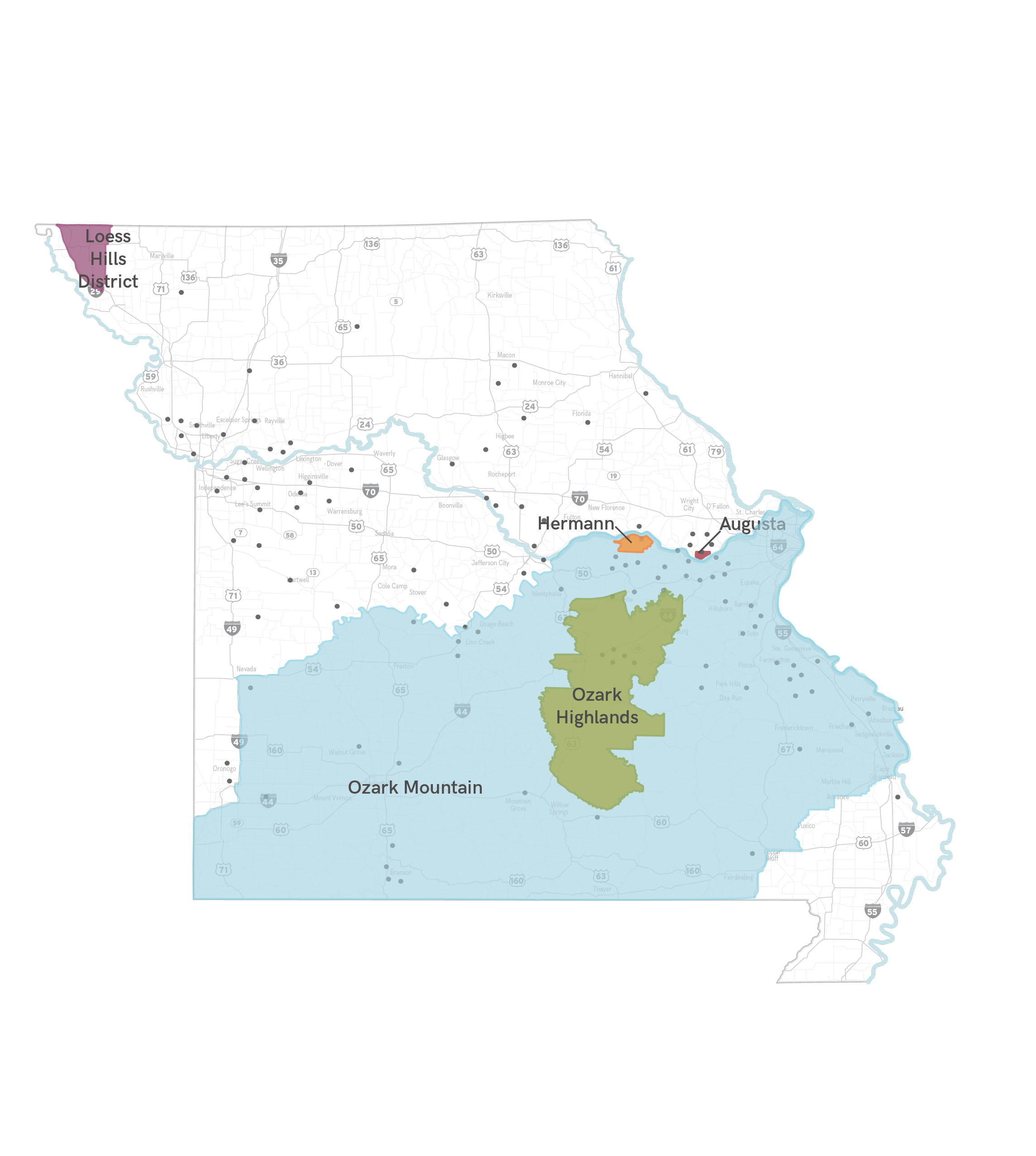
An American Viticultural Area (AVA) is a designated wine grape-growing region in the United States distinguishable by geographic features, with boundaries defined by the Alcohol and Tobacco Tax and Trade Bureau (TTB). Missouri is home to the country’s first designated AVA.
AUGUSTA AVA
The first AVA in the United States was accorded to Augusta, Missouri on June 20, 1980. Seven California districts and one in Oregon had filed applications with the Bureau of Alcohol, Tobacco and Firearms; however, the honor went to the 15 square mile area surrounding Augusta. The bureau cited the unique soil, climate and wines, as well as Augusta’s long history as one of America’s oldest and foremost grape and wine districts. In the mid-1800s German immigrants found the Missouri River area just west of St. Louis to be well suited for growing grapes. Napa Valley was the second AVA named after Augusta on January 28, 1981.
OZARK MOUNTAIN AVA
The Ozark Mountain AVA was established on July 2, 1986 and covers a vast 3,500,000 acres in southern Missouri, extending into northwest Arkansas and northeast Oklahoma. The Ozark Mountain AVA is so large, several smaller AVA’s lay within its borders, including Augusta, Hermann and Ozark Highlands. It is the sixth largest AVA in the United States.
HERMANN AVA
The Hermann AVA was recognized on Auguts 18, 1983 and consists of 51,200 acres in the Hermann area between St. Louis and Jefferson City, Missouri. German immigrants settled the Missouri River Valley area in the 1830s and began planting vineyards in what is today one of the most historic wine regions.
OZARK HIGHLANDS AVA
The Ozark Highlands AVA was designated on August 31, 1987; although the grape growing tradition goes back to the 1870s. The fourth accorded AVA in Missouri encompasses 1,280,000 acres in south-central Missouri, covering portions of eleven Missouri counties including the town of St. James, Missouri.
LOESS HILLS DISTRICT AVA
The Loess Hills District AVA was established on March 3, 2016 and consists of 12,897 square miles of loess-based hills comprising a long, narrow region along the western banks of the Missouri and Big Sioux Rivers in western Iowa and northwestern Missouri. The topography is characterized by rolling to steep hills. The deep loess enables grape vine roots to reach deeply into the soil and allows water to drain quickly.